Agriculture Satellite Images To Power Up Daily Crop Tracking
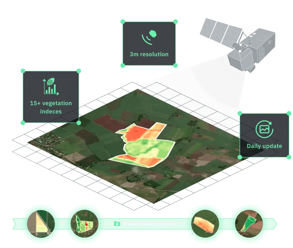
Frequent high-resolution farm satellite imagery gives you the edge needed to manage crops more precisely, efficiently, and confidently. Make informed decisions with current and historical images combined with powerful analysis and forecasting tools, all in one platform:
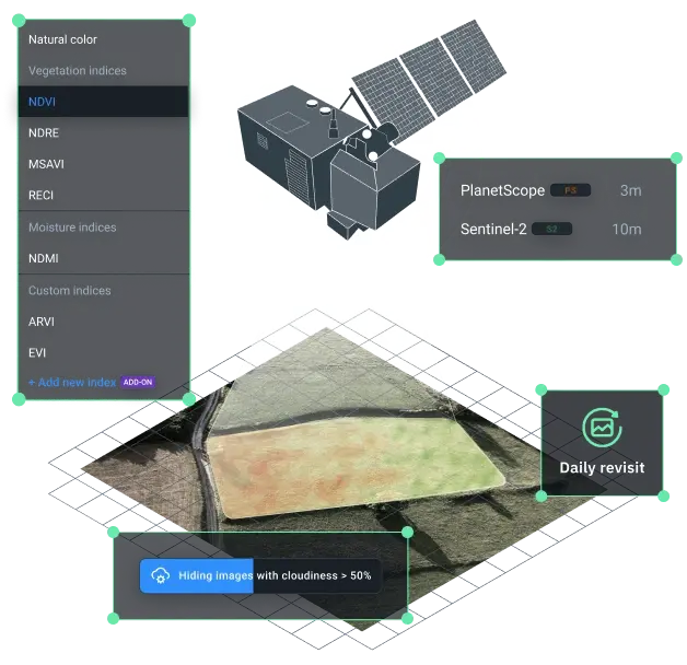
- 3m-resolution images for accurate detection of field anomalies
- Daily updates for cloud-free, consistent imagery
- 15+ vegetation indices to assess the field state
- 5-year archive for field history and trend tracking
How to use high-resolution satellite imaging in agriculture
Monitor crop health state and changes daily with field-level agriculture data
Catch disease, pest, and stress signs with vegetation analysis and risk alerts
Optimize intervention timing by tracking plant growth stages and health issues
Precision agriculture satellite imagery at work on real farms
Satellite imaging agriculture already supports effective crop monitoring in modern farms by showing field-wide health trends. But the real advantage comes with daily, high-resolution satellite data for agriculture. It provides the detail and speed needed to spot trouble early and know exactly where to intervene.
Optimizing agriculture water use based on high-resolution satellite data
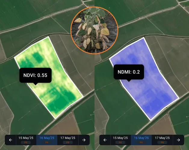
With ground-based point measurements, water stress in crops is often overlooked until it causes significant harm. To catch it early, a Chilean agri-tech company turned to high-resolution agriculture images from PlanetScope integrated into the WHY Crop Monitoring platform. The team uses NDVI and NDMI to follow crop growth based on the BBCH scale, detect low moisture levels, and identify early signs of water stress. On a regular basis, they review updated agriculture imagery, weather forecasts, and soil data to give clear irrigation advice for each field. Over 80% of their projects now rely on detailed (up to 3m-resolution) satellite images, taken up to four times a day, to guide their irrigation decisions.
What the farmer gains:
- Early detection of water-related crop stress
- More precise irrigation timing based on field data
- More efficient water use and improved crop resilience across all monitored fields
Targeted fertilizer application across large areas with hi-res images
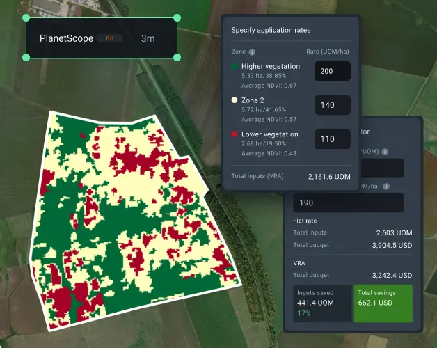
Accessing PlanetScope high-resolution images through WHY Crop Monitoring changed the game. With our crop growth monitoring system, the team pinpointed low NDVI areas that matched regions with poor nutrient uptake. They used EOSDA's variable rate application (VRA) feature to generate a nitrogen map tailored to each zone. Integrating PlanetScope images into their nitrogen maps allowed for more accurate fertilization and more even crop growth across the field.
What the farmer gains:
- Saved 18% on inputs thanks to optimized nitrogen use
- Yield increase by 9% thanks to targeted fertilization
- Full yield potential unlocked in top-performing zones
Early Pest Detection In Sri Lankan Agricultural Zones
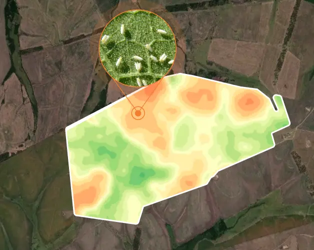
Brown planthoppers and leaf miners can spread fast in Sri Lankan paddy and vegetable fields. Farmers lacking precise monitoring often spray too late or treat entire areas just to be safe. A local agronomy advisory, using WHY satellite imagery integrated into the WHY Super App’s Agricultural Module, avoided this scenario by tracking farmers’ fields through high-resolution data and AI-based alerts. When vegetation index values dropped slightly in several paddy plots, the system raised a flag. Field scouting confirmed early pest activity along field boundaries. With this insight, officers identified specific treatment zones and guided farmers to apply insecticides only where needed.
What the farmer gains:
Pest damage contained
Spraying area reduced by 60%
Protected over millions of worth of harvest
Why check agriculture satellite imagery on WHY Crop Monitoring?
Still have a question?
Fill out our contact form, and we'll get back to you quickly. We're here to help!