Monitor. Сontrol. Prosper — Smart Farm Risk Protection
Oversee crops, access detailed analytics, and make informed decisions — all through our easy-to-use online crop management software.
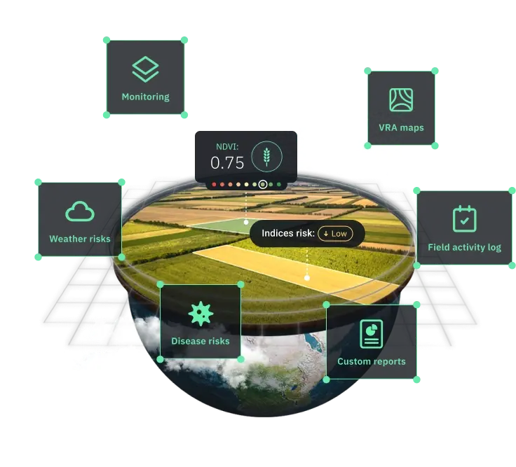
Agriculture Software for Precision Risk & Resource Management
Behind the Scenes of WHY Digital Agriculture Solutions
WHY Crop Monitoring is a cloud-based agriculture software product that turns satellite data into practical insights for precision field management. We integrate satellite technology with AI-based analytics and machine learning, backed by expert agronomy knowledge, spotting farming patterns and potential risks unseen by the naked eye.
Our agriculture management software processes large volumes of geospatial data to help farmers and agriculture professionals monitor lands, analyze crop performance, and plan confidently. We make it easier to track changes, detect issues early, schedule activities, and collaborate effortlessly through shared digital field maps and reports.
Remote Field Monitoring with Satellite Data
Stay connected to your multiple fields without stepping outside. Use our digital agronomy software to access ready-made insights without complicated setups.
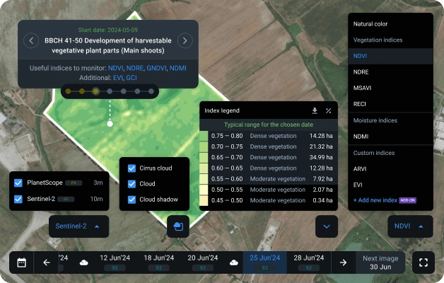
- High-resolution (up to 3 m) satellite imagery by Sentinel-2 and PlanetScope
- New satellite images daily
- Risk notifications delivered on-platform and via email
- Over 10 built-in vegetation indices
- Custom indices available upon request
- Filters to remove clouds, cirrus, and cloud shadows
- Index suggestions matched to plant growth stages
- Typical ranges for NDVI, NDRE, and MSAVI indices
- Accurate model-based yield prediction
- BBCH stages' timeline based on sowing dates
Benefit from our precision agriculture tool: gain a clearer view of vegetation conditions, make faster and more informed decisions, and improve productivity through precision farming practices.

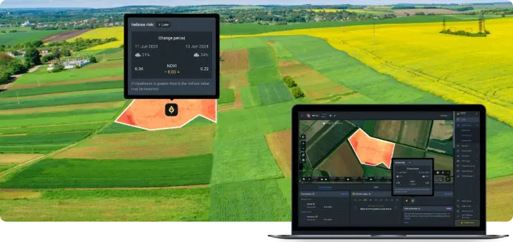
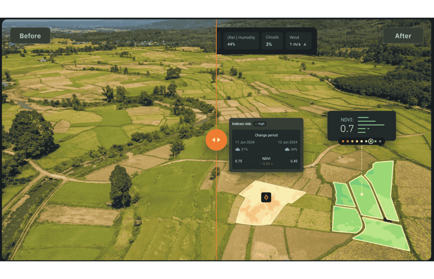
Risk Map
Stay on top of potential agriculture risks: diseases, extreme weather, and shifts in vegetation indices across all your fields. Identify issues early through digital precision ag tools, without day-to-day on-site inspections.
- Comparison of NDVI values between the two newest Sentinel-2 images
- Disease and pest infestation risks based on plant growth stages and weather forecasts
- Extreme weather risks like heat/cold stress, high winds, and heavy rains
Benefit from our precision agriculture tool: catch early warning signs, take swift preventive measures, and protect yields from losses.
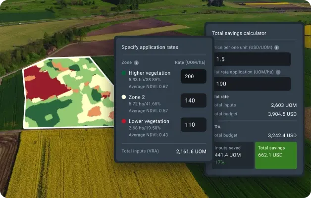
VRA Maps
Optimize agriculture inputs with smart farming software. VRA maps help you apply seeds, fertilizers, pesticides, desiccants, and water with precision — where and how much they are needed — minimizing waste and maximizing farming returns.
- Maps for variable rate seeding
- Maps for variable rate fertilizing
- Maps for variable rate desiccation
- VRA maps based on yields
- Custom and multilayered VRA maps based on NDVI, NDMI, RECl, MSAVI, elevations, or precision ag machinery data
Benefit from our precision agriculture tool: reduce input costs, improve field productivity, and increase your total yield by bringing precision to resource distribution.
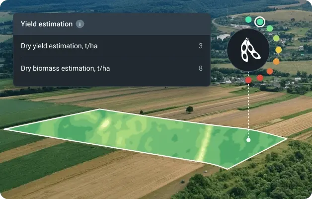
Yield Estimation
Stay ahead of agriculture productivity with the accurate yield estimation tool. Our crop planning software analyzes vegetation type, irrigation details, weather data, and other key farming factors to project yield and biomass 14 days in advance.
- Dry biomass estimation. Available 1–2 weeks after sowing, right after plants emerge above the soil
- Dry yield estimation. Calculated when productive plant parts become visible
- Recommended harvesting date. Available 14 days before the optimal harvest time, based on model predictions
Benefit from our precision agriculture tool: enhance crop management through informed agriculture forecasting, plan fieldwork with confidence, and harvest at the right time to maximize yield.
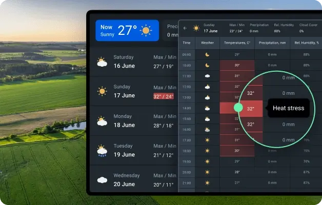
Weather Analytics
Weather conditions impact every stage of agricultural production. With our digital farming tools, you get reliable 14-day forecasts, access to historical data since 1979, and tools to track cold and heat stress. Use this information to schedule critical activities like spraying and tillage more effectively. Integrate ground weather stations to further improve accuracy for your fields.
- Global weather data with a 90x90 meter resolution
- Alerts on weather risks
- Hourly weather forecasts tailored for agriculture
- Weather analytics using historical data from 1979 onward
- Simple integration of ground weather stations
- Weather and vegetation insights on a single digital farming platform
- Data sourced from international providers and advanced forecasting models
Benefit from our precision agriculture tool: adjust watering to precipitation, identify and mitigate risks from extreme weather events, and schedule fieldwork with greater precision, avoiding weather disruptions.